The problem of determining longitude at sea was one of the most significant navigational challenges faced by sailors and explorers for centuries. Prior to the 18th century, navigators could determine their latitude - their distance north or south of the equator - by observing celestial objects such as the sun, moon, and stars. However, determining longitude - their position east or west of a fixed point, such as the Prime Meridian - was much more difficult. This challenge was especially significant for long-distance travel, exploration, and trade, where a ship's position was critical for reaching its destination safely and efficiently.
In the early days of navigation, sailors relied on dead reckoning, a method that involved estimating the ship's position based on its last known location and its estimated speed and direction of travel. However, this method was often inaccurate, and sailors had to rely on other methods, such as sighting land or using rudimentary tools such as compasses and hourglasses. As travel and exploration expanded, there was a growing need for a more accurate method of determining longitude at sea.
In the 16th and 17th centuries, astronomers and mathematicians worked on developing new methods for determining longitude. One of the most promising solutions was based on the observation of the moons of Jupiter, which have predictable orbits. By measuring the time when the moons passed behind or in front of Jupiter, navigators could calculate their longitude accurately. However, this method required highly accurate telescopes, which were not practical for use at sea.
Another method involved using the position of the moon relative to the stars to determine the time at the observer's location. This method required accurate tables that predicted the position of the moon at any given time, but these tables were complex and difficult to use in practice.
The problem of determining longitude became so significant that various governments and organisations offered rewards for anyone who could develop a practical method for its determination. One of the most famous of these rewards was the Longitude Prize, which was offered by the British government in 1714. The prize offered a reward of £20,000 (equivalent to over £3 million today) to anyone who could develop a practical method of determining longitude within 30 nautical miles (56 km). This prize spurred many inventors to work on developing new methods for determining longitude.
One of the most significant breakthroughs in the problem of determining longitude came from a clockmaker named John Harrison. Harrison was a self-taught clockmaker who had been interested in timekeeping from an early age. He became fascinated with the problem of determining longitude, and he believed that a highly accurate clock could provide the solution.
Harrison developed several prototypes of marine chronometers, or highly accurate clocks that could keep time at sea despite the motion of the ship. His first prototype, known as H1, was developed in the early 1730s and was accurate to within about 10 seconds per day. This was a significant achievement, but it was still not accurate enough to meet the requirements of the Longitude Prize.
Harrison continued to refine his designs, and he developed a series of prototypes that were increasingly accurate and durable. His second prototype, H2, was accurate to within about 5 seconds per day, and his third, H3, was accurate to within about 1.5 seconds per day.
Despite these achievements, Harrison faced significant opposition from the scientific establishment of his day. Many astronomers and mathematicians believed that the problem of determining longitude was too complex to be solved by a simple clock. They argued that the motion of the ship and the effects of temperature and humidity on the clock would make it impossible to keep accurate time at sea.
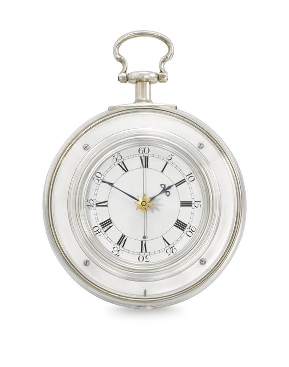
Harrison was undeterred, and he continued to refine his designs. His fourth prototype, H4, was accurate to within half a second per day, and his fifth, H5, was accurate to within a tenth of a second per day. These clocks were also durable and reliable enough to withstand the rigors of long sea voyages.
Harrison's marine chronometers were finally put to the test in 1761, when the Royal Navy commissioned him to accompany a fleet on a voyage to Jamaica. Harrison's H4 chronometer was used to determine the longitude of the fleet, and the results were accurate to within a mile. This was a remarkable achievement and proved that Harrison's marine chronometers were a practical solution to the problem of determining longitude at sea.
Despite this success, it took several more years for Harrison to receive the full reward for the Longitude Prize. He faced significant opposition from some members of the scientific community, who questioned the accuracy of his chronometers and argued that he had not met all of the requirements of the prize. However, with the support of several influential figures, including King George III, Harrison eventually received the full reward in 1773, more than 40 years after the prize was first announced.
Harrison's marine chronometers revolutionised maritime navigational safety and had a significant impact on maritime travel, exploration, and trade. With a reliable method for determining longitude at sea, ships could travel more efficiently and safely, and new trade routes and exploration opportunities became possible.
In addition to Harrison's marine chronometers, other methods for determining longitude also emerged in the 18th and 19th centuries. The development of accurate sextants, which allowed navigators to measure the angle between celestial objects and the horizon, made it possible to determine longitude using the position of the stars. This method, known as celestial navigation, is still used today, although it has been largely replaced by electronic navigation systems.
In conclusion, the conquest of the problem of longitude was a significant achievement in the history of navigation and exploration. For centuries, the inability to determine longitude accurately had limited the ability of sailors and explorers to travel safely and efficiently. The development of practical methods for determining longitude, including John Harrison's marine chronometers, revolutionised navigation and had a profound impact on global trade and exploration. Today, the problem of determining longitude has been largely solved, but the legacy of the pioneering navigators and inventors who solved this problem continues to shape our world.